|
|
|
by Alisa Slaughter Like so many things, borders are often defined by what they are not. One example: on a long-distance bus between Navojoa and Ciudad Obregon, in Southern Sonora, the driver cued up “Bring It On,” dubbed in Spanish, and for two hours we passengers contemplated the trials and amours of California’s gilded cheerleaders. “!Somos porristas!” the girls insisted, in tones of reverence and awe. We’re cheerleaders! In Mexico’s pragmatic desert heart, the movie’s weirdness resounded. Occasionally another passenger caught my eye and looked either puzzled or complicit, even amused.
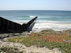
Place names resonate, even when they don’t fit. Biologists say that migrations work in all directions, not just north to south, and so in the summer of 2001, I turned my back on the Pacific – the turbulent ocean with the peaceful name – and traveled east toward the Gulf of Mexico, a journey along a figurative gulf in three dimensions. Playas de Tijuana A Northern Harrier skims the hills above Playas de Tijuana, the white stripe across its flanks flashing at each pass over the brown hills. All afternoon it slides over a no-man’s-land of arroyos split by upended metal runway, scene of the latest attempt by the U.S. government to control its border with Mexico. Like all harriers, this one has geometry lodged in its mind: bird jargon refers to a harrier “quartering” a marsh and this raptor is doing just that, dividing bits of territory into fractions and patrolling them with the delicate commerce of hunger always calling the shots. The soaring predator weighs the cost of expending energy against the benefit of catching an occasional rodent, and evolution has rewarded its military precision. Watching the raptor at work, it’s hard not to tease out the embedded rhetoric: birds fly unrestricted here, crossing at will a messy collision of nature and technology that stretches hundreds of miles to the east. Double fences, lights, sensors and constant passes by green-striped Jeeps demonstrate how far people north of the border will go to separate one bit of geography from another, but even a billion dollars can buy only so much certainty. Mexicans still cross, here, throughout Tijuana, and past the spot where this section of fence ends, 14 miles from the Pacific. From there, the border stretches through the Sonoran and Chihuahuan deserts, divided by barbed wire, Progressive-era concrete monuments, occasional fortress installments at towns and cities, and finally the Rio Grande, a thin, steamy line of green through the tumbled rocks of Chihuahua and South Texas. It’s a terrible place to wander around on foot in summer, but there are meatpacking plants in Nebraska, fruit orchards in Oregon, carwashes in Los Angeles, all hiring.
Another reason to roam this scorched landscape is to look at wildlife, birds especially. This is a good place for them, the intersection of a rich array of habitats for outer-space species like chachalacas and purple gallinules in South Texas, showy oddballs like the Elegant trogon and sulfur-bellied flycatcher in southeastern Arizona, and wandering weirdos like the blue-footed booby and exotic orioles in California’s southernmost counties. Just up the beach on the San Diego side, the threatened Least tern maintains a nesting colony, protected from—and by—humans. Pedestrians are kept out by signs and flimsy orange snow fencing, but it’s mostly an honor system. A fellow birdwatcher, standing on a rise of sand overlooking the tern colony, once told me he thinks the bigger the fence, the safer the birds, and he wasn’t talking about the orange plastic, but the metal a few hundred yards south. “How long do you think these birds would last with those people traipsing through all night?” Those people. My former teacher, the late Edward Abbey, really liked vultures. His admonition to a desert wanderer dying of thirst is to take comfort in the certainty that eventually the carrion-eaters will loft him skyward: “For most of us a promotion in grade, for some the realization of an ideal.” But the key to the problems of the Navajo, and the surrounding natural environment, according to Abbey, was “fewer Navajos.” It seems like a ballsy statement for a guy from Pennsylvania to write while squatting in a trailer in southern Utah, but Abbey was given to those, half the time, it seems, to push readers to decide on the spot how far they’re willing to go with him, and against the human race. I remembered Abbey as my students and I struggled up the beach from the tern colony and a light plane flew over, one of those aerial jet-skis you can build from a kit. It flew low enough to be annoying to us and dangerous to the birds, who were feeding and playing in the air, and the leader of our group shook his fist at it: “The son-of-a-bitch shouldn’t be out here.” He seemed very sure. Abbey would have been sure enough to shoot it down. Maybe. He did like his pickup trucks. Today at Playas de Tijuana, under the eye of a lounging border patrol agent, there are no crossers in sight, and, apart from the harrier and a scattering of gulls, few birds among the festive groups of Mexicans enjoying their Sunday. Instead, at the portion of the fence where solid metal gives way to metal mesh for a few yards, a family is holding a reunion of sorts: one couple in their 50s on the Mexico side, another young couple with children on the U.S. side, various adults and children on the Mexican group’s perimeter. It’s Mother’s Day and the fence appears to be the only place where this family can hold a party. The young woman on the U.S. side holds up a pink-ruffled baby; the older woman on the Mexico side wiggles her fingers through the mesh. Like other segments of the border fence through Tijuana, this portion is inscribed with the names of people who have died trying to cross. Below is a monument of a more utilitarian sort: at the edge of the surf, someone has neatly sawn away a chunk of metal bars. Past the hole, the fence extends into the Pacific, past the breakers, far enough that the mathematics of possibility meet the mathematics of danger. Put enough barriers up, in other words, and eventually too many people die trying to cross, weighing the danger of surf or patrols or desert against whatever is chasing them from their homes. One could call this “deterrence.” But it hasn’t halted the flow of people to the north. The Best of All Possible Worlds Candido is from Puebla. He has brothers and sisters; it isn’t clear how many. He looks 14, but says he’s 16, with thick, straight black hair, dark skin and innocent, wide-set eyes. When he talks about his mother, his mumbles become unintelligible. Whatever he’s been doing to survive since he left home, making his life now on the packed dirt down the street from the Loncheria La Pasita, it probably wouldn’t give his mother much joy.
Pre-fence, this bit of Tijuana’s Colonia Libertad above the flat area known as “the soccer field” was a wild scene, hosting hundreds of crossers who waited for nightfall to sprint for San Diego’s tawny hills. Now, the owner of the loncheria has one son in a U.S. jail, serving a three-month term for smuggling, and business is bad: what customers wander in are the desperate from far inside Mexico, people from Oaxaca and Chiapas and Guerrero, who haven’t heard yet that they can’t possibly cross at the soccer field anymore. Or they’re the borrachos and predators who watch for easy pickings, those newly arrived from the south, and those newly dumped on the streets of Tijuana by the Border Patrol. Moving between the two groups are young survivors, teenaged boys like Candido who still come across as children, not hustlers. The scars on Candido’s face run from the corners of his mouth to the centers of his cheeks, long slashes with a regular constellation of smaller holes marking the still-babyish skin. Several other gashes, still swollen after a year—it’s been a year, he says—cover his hands and forearms. He was hurt running through the no-man’s-land somewhere east of San Diego, barreling at full speed into a line of barbed wire that caught him in the mouth like a gag, tangling in other strands that sliced his arms and torso. Despite the damage, or maybe because of it, he seems proud of his abilities as a decoy. Once he got caught crossing and the Border Patrol agents made him wash trucks the next morning. But it was a Migra doctor who patched him up after he tangled with the fence. Or so he says. One of our group is asking him leading questions, and Candido seems practiced at telling people what they want to hear. Candido, and the family at the border fence in Tijuana, are as rhetorically powerful as the harrier is symbolically powerful. It’s tempting to deploy them all, a small living salvo against the very many people who seem so sure of their positions on immigration issues. It’s easy to dismiss the jingoists, the English-only paranoiacs, the self-appointed culture police. It’s harder to turn away from the environmental arguments, which often come from my friends. Typical are two highly regarded scientists who ended a blunt article in a recent issue of a well-respected and beautifully produced semi-scientific publication with an even blunter demand: to protect the environment (the U.S. environment alone, presumably) legal immigration should be seriously limited, and illegal immigration should be “halted.” Maybe they’re right. Maybe. But I wonder if they realize what it would mean to “halt” illegal immigration, if they have the stomach for it. Nobody can say for sure how many people die crossing the border each year, but the number that’s been coming up lately hovers around 400. Certainly, 14 miles inland is further than the cooling effect of the Pacific Ocean can stretch, ending before the metal barrier. From the end of the fence east to Matamoros on the Gulf of Mexico, there’s hardly a stick of shade or a drop of water—unless you count the steamy banks of the Rio Grande or the salty dregs of the Colorado. The few oases of clean water and trees coincide with the few nerve-wracked border towns and cities: Calexico/Mexicali, Yuma/San Luis Rio Colorado, the twinned cities of Nogales in Arizona/Sonora, El Paso/Juarez, Presidio/Ojinaga, Brownsville/Matamoros. Most of them are split by that 10-foot metal fence, interlocking panels salvaged from portable runways last used during the Gulf War. Away from the towns, there are few fences, only an occasional bank of portable stadium lights emerging like some supertall, surprising sort of cactus from the desert. Nearly every patch of mesquite and tamarisk from San Diego east, at least every patch large enough to afford shade and cover, hides a green-striped vehicle, “limas verdes,” or green limes in border slang. But the main barrier is the land itself, an expanse of sun-whitened, heat-hazed bajada telescoping the waist-high vegetation to nothing.
Naco It’s Memorial Day, but not in Naco, Sonora, where children in school uniforms are on the move in search of helados. We buy some too, dense frozen clumps of chopped strawberry and mango, and a man lounging in the cool building says that the next time we come to Naco it’ll be different. “Bigger, lots of people,” he says. “Espero que no,” I answer, the fortified compounds of Tijuana’s maquiladoras fresh in my mind. Everyone in Tijuana who can afford it buys drinking water, and south of Yuma the Colorado River trickles so low the children of San Luis’s shantytowns must tip plastic buckets flat on their sides to fill them. But there’s enough water to irrigate the odd crescent of grass outside the foreign-owned factories, and to run Tijuana’s electronics industry, which requires ample clean water. Whatever Naco has that will help it grow, investment by the gringos probably won’t increase anything but problems. But who am I to say? The U.S. government considers the border region a social and environmental trouble spot; to many in Mexico, it’s the center of the country’s economic dynamism, a locus of hope. The teenager behind the ice cream counter keeps his eyes on the floor, refusing to comment. What does he want? Presumptuous to guess that he wants things to stay the same in one of the few pleasant border cities on the great chain—but maybe condescending to guess that he does not.
Across the line, there’s evidence that all is not peaceful along this stretch. One hand-lettered sign reads: “If this were Scottsdale, the National Guard would be here.” (My brother-in-law’s response, “If this were Scottsdale, you wouldn’t be here,” seems cruel but apt.) Other signs refer to drugs and “invasions” of illegal immigrants, linking two different issues that in many cases share only geography. If the justification for this kind of bitterness is chimerical, the effects are real. In January, vigilantes opened fire on a smuggler, who panicked and drove into the All-American Canal in Imperial County, drowning his passengers. It happened on the very same roads I drive each fall with my students, looking for burrowing owls, a bird even the most cynical college freshman deigns to call “cute.” Afraid of a plunge into the canal that claimed the immigrants, I always unsnap my seatbelt and roll the window all the way down, this in broad daylight with no one shooting. La Ruta The U.S./Mexico border, especially in the slow summer months, feels like a military zone, a sleepy one. At each of several checkpoints between San Diego and Brownsville, we pull up to a stop sign, sometimes shaded, often not, and an agent, always young, always polite, often Latino, asks a couple of questions, all the while scanning the inside of our car with his eyes. We drive a Honda Civic, so he has to scrunch down and stick his head in the window, trying to be unobtrusive about it. What are we doing there? Looking at birds and camping. Camping? Well, not every night. If it’s too hot, or too weird (the deserted state park at Falcon Reservoir, for example), we get a room. We explain ourselves, the agent decides against searching our car, we’re waved on.
Some areas are so saturated with patrols there’s hardly any vegetation left between the off-road tracks. Looking for a black-backed oriole one day in the hills east of San Diego, we prompt a farcical stream of investigation: one lima verde after another nosing through the trees, stopping, backing out, while a restless cohort boils dust on the pounded ridge-lines above us. (We see the bird, a rare vagrant from Mexico, but it looks edgy, ready to leave.) We’ve heard of birdwatchers stopped and detained while agents call in license and description: anyone poking around here could be a smuggler, or a lookout for smugglers. We’ve also heard of birdwatchers robbed of money, equipment, vehicles, by scary men on both sides of the border, most recently in the same canyon we choose for a campsite north of Naco. After a while, the message comes clear: this is a dangerous place, a place where you will be stopped and called in and even searched. Somewhere outside El Paso, I start to speculate: if civilians avoid the border, the few remaining will seem more suspicious, more deserving of hassles. What are you doing here? People are already cranky: a sign in Columbus, New Mexico, proclaims “You do have rights” and lists a phone number to report Border Patrol abuses. When it’s just Migra and crossers and the few people who live in those sparsely populated, mostly poor areas, what chance does the civility of the nice young checkpoint agents stand? And when most of the people wandering the hills and bajadas are desperate immigrants who have every reason to avoid the police, it’s little wonder that the area remains a magnet for the bandits and vigilantes who prey on them and anyone else who shows up. It’s not often that tourism feels like civil disobedience, but along the U.S./Mexico border in the summertime, it comes close. Vermivora Crissalis The Colima warbler (Vermivora crissalis) is a drab little yellowish bird, an unexciting Easter egg in a chunk of North America that looks miniscule on a map and feels larger on foot. We’ve walked ten miles through the Chisos Mountains, run out of water, developed one case of heat rash, nearly swiveled our necks off looking for a winged creature that reportedly likes the tops of trees growing on this particular mountain range in Texas. The store at Big Bend National Park’s visitor’s center sells cold sodas and stale moon pies, one of the benefits of being in the South and ample compensation for not seeing the bird. Moon pies are better stale, and sometimes missing a bird is just fine: a good excuse to come back, or maybe go see it where it’s more abundant, like Mexico. No big deal. Looking at birds provides an alibi for being outdoors all day, rare birds are often drab, and pretty birds are wonderful even if they’re common as dirt, such as the green jay that shows up at every feeder in south Texas: a surreal creature with a black mask, yellow belly and green-blue back and tail. There are ways to take all this more seriously, of course, even for amateurs. In California, Texas and Arizona, rare or local species like the Green and the Mexican jay and the red-faced warbler are referred to as “Mexican specialties,” birds that inhabit a tiny bump on the range map north of the Mexico border, at the far northernmost part of their ranges. To see them in more predictable habitat, where they are often common, one would have to cross into Mexico, and doing that renders a bird “uncountable” for purposes of some (not all) forms of amateur competition. For serious birders, an out-of-place Mexican species in Arizona or Texas is more valuable than the same bird in Sonora or Chihuahua. The border lends species their value as competitive markers, and also takes it away. There are people who compete for “world birds” and even Mexican birds, but many hard-core birders are “North American” listers, and North American to them means the U.S. (exclusive of Hawaii) and Canada. It’s worth wondering how such a consuming preoccupation with rare birds north of the border must color attitudes toward the environment to the south. It’s likely little different from the rest of the population: among birders I’ve noticed everything from indifference to xenophobia to active concern for not only the birds but the plants and humans of Mexico. But looking at the labor bottlenecks in Tijuana and Juarez, it’s hard to escape the comparisons: a woman who makes ten dollars a day at a factory in Tijuana walks a hundred yards and is suddenly worth ten an hour doing the same job. Bird “rarities” that stray up from far south in Mexico are worth more than common border species, but it’s the poorly-dressed, dark-skinned indios from Mexico’s southern states who are most likely to be spotted and deported by the Migra; some are more illegal than others. A “Mexican” bird that breeds on the north bank of the Rio Grande is cause for celebration and disbursement of study grants: it’s expanding its range. But a Mexican woman who has a child in El Paso is viewed as subversive and even criminal. Free Junie Redford, Texas, is quiet. St. Joseph’s church is locked and the only store in town is closed, but the cemetery, open for business, flutters with colored ribbons and bristles with wreaths. It’s high noon and far too hot to stop and browse the headstones, but among them is likely buried goat herder Esequiel Hernandez, a U.S. citizen shot in 1997 by Marines assisting the Border Patrol. It seems like a particularly terrible, desolate place to die, a landscape not hilly so much as creased, folded, flung into sudden elevation gains made stark by the lack of vegetation. With all the little slot canyons and arroyos, it’s an easy place to lay an ambush, and blood on the border is an old tale in these parts: Juan Rulfo’s short story “Paso del Norte,” which dates from the early ‘50s, tells of a beleaguered, slow-witted man who nearly has his elbow shot off when he tries to cross into Texas. He drags himself into Ojinaga, Presidio’s twin on the Mexico side, and tells his story to a cop, who answers that the shooters must have been “the Apaches.”
Down the road from Presidio, the latest version of the Texas “Apaches” are considering a big NAFTA highway through Presidio, one that will link the vegetable-growing areas of Sinaloa with the middle of the U.S. It’s a popular idea here—less so in quaint towns like Marfa and Alpine that trade in tourists, not imports. Outside Presidio there is one tourist trap, Fort Leaton State Historic Site. It’s called a fort, but it was really a private residence for most of its existence, and among its early owners was an American who made his money selling Apache scalps to the Mexican government. Presumably the dioramas are referring to a different population, not the Apaches who shot at Rulfo’s hero. The town itself seems edgy, with another spate of hand-lettered signs, most of them brief: “Junie is innocent.” Others are more substantial, including a long disquisition in Spanish addressed to President Fox and attached to a house on the highway. They all refer to Jesus “Junior” Herrera, a Presidio businessman accused of killing a journalist on the streets of Ojinaga and now caught in Mexico’s fine-grinding Napoleonic legal system. Residents of Presidio and much of Ojinaga are dismayed, and whispers are circulating of corruption, drugs, women.
Apaches. This strain lives on both sides of the line, it appears, and has little to do with the actual tribe now running a successful ski resort a few hundred miles northwest in Arizona’s White Mountains. There’s a heat wave on in South Texas—a cruel joke, really, to announce that. It’s too hot to camp if we want to sleep, so we check into a noisy hotel in Del Rio, buy ears of corn with lime and chile powder, listen to the shouts of carousing fishermen from below. There’s a bass derby going at the now-ironically named Amistad Reservoir, and the lucky winners get to share a $15,000 purse. “A Fistful of Dollars” is on television. Del Rio is vibrant and gritty, and it’s between here and Laredo that we begin to see lines of scissor-tailed flycatchers, graceful streamer-tailed birds, pearly-gray and white, with salmon flashing under their wings as they leap off roadside perches to catch bugs. They’re so beautiful we risk mangling our tires in roadside mesquite to look at them (the wide shoulders of Texas highways act as informal passing lanes and only a lunatic would park there) and so common that they seem to have become all but invisible to the locals. A senior Border Patrol agent is quoted in the San Antonio Express-News the day we hit Brownsville, responding to the perennial question: Why not open it up? It does indeed seem counterintuitive to continue the heartbreaking and futile process of militarizing the area, bullying and repatriating people like the two men we see taking a furtive, impromptu bath at a hotel fountain in Matamoros. They are walking away from the border and look as if they’ve spent the night in the bush, or maybe in an Immigration Service bus. They look like Candido, very dark and straight-haired, indios from Mexico’s interior. They also look exhausted to the point of weeping, marked as visibly by fear and bewilderment as Candido was by the wire.
It would be a lot to expect a Border Patrol agent to advocate opening up the border and this one doesn’t. But his rationale seems weird at first. Half of Matamoros would be in Brownsville the next day, he says. And then instead of having the border where it is, we’d have it a few hundred miles north. I look around Matamoros for a few hours. The exhausted Rio Grande sometimes renders the city’s water system a little temperamental, but on a Thursday morning the town seems to have recovered from its invasion by the U.S. a century and a half ago: prosperous enough, people doing business and looking purposeful, fountains and faucets running as intended. I eat lunch next to a table of women in crisp white medical uniforms, all of them turned out impeccably and ordering steak with mushrooms. Surely the Border Patrol agent doesn’t expect the residents of Matamoros to walk away from all of this? He is referring, surely, to the men at the fountain. And when he refers to “the border,” he can’t mean the line on the map. He’s using “the Border” as code for “low wage workforce,” perhaps. Is that all? At a store in Terlingua a sign in the restroom asks, in English and Spanish, that all toilet paper be thrown in the wastebasket. This would appear to be a Texas town with a Mexican septic system. In Brownsville, another restroom notice, in exasperated English, asks or rather demands the opposite: “Do NOT throw toilet paper in the wastebasket!” It’s easy to imagine the incomprehension of people who learn early that only thoughtless barbarians risk clogging up a toilet with paper, and the frustration too of the store owners, who note with disdain that “those people” persist in what seems like an unsanitary habit. And then they hand-letter another sign, in English, with capital letters and lines under the words. So this, too, is the border, a clash of habits formed by abundance, and habits formed by limits. Is this what makes my tern-loving friend so nervous? My legs look like someone set fire to them and then put it out with a hatchet. Heat rash and missed birds seem to coincide. On the bridge between Matamoros and Brownsville, we search one last time for green kingfisher (small, quiet, and hard to spot) and ringed kingfisher (big, noisy, and easy to spot.) There’s no sign of either, and it’s so hot the streets of Matamoros seem ready to burst into flame. We’re at the bottom end of tropical storm Allison, which has stalled over Houston, our last stop, and the heat and humidity know no limits in South Texas. On the day we drive from Brownsville to Corpus Christi, both cities report record high temperatures. We’re beginning to see roseate spoonbills, reddish egrets, tricolored herons, more edge-dwellers who reach their northernmost ranges along the Gulf coast. In a weird incidence of culture imitating nature, we observe a shift along the Rio Grande. The Spanish common name for a variety of waders is “garza,” and that’s the most common surname we encounter in south Texas: Garzas in business, in the newspapers, on billboards, running for office, running from the police. They far outnumber the Garcias and Sanchezes we’re used to seeing in California.
We drive north through increasingly heavy air. An alligator blocks our way on a trail, Texans in pickups brush our little car onto the shoulders of two-lane highways as if we aren’t there. It’s started to rain again in Houston, we learn as we drag ourselves into a hotel room on Galveston Island. We’ve just come back from looking at gulls along the shore and reading memorial plaques dedicated to the victims of Galveston’s mighty flood. Black skimmers plied their underbites on the waves on one side of the esplanade; we were thoroughly mooned by carousers in large pickup trucks on the other side. They are a vigorous folk, these Texans. Aside from the festive spirit and ominous weather, things are different in Galveston. The minute we turned north from Brownsville, the rest of the country, the one that exists apart from the border, reasserted itself with an almost audible click. The green-striped patrol vehicles disappear, and Spanish gives way to the mixed cadences of the Anglo and African-American South. Houston
If Candido and the Tijuana family are rhetorical in one direction (“oppression”), what kind of suasion can I expect from an endangered bird? “Loss,” perhaps? There’s nothing like a few weeks on the border to make you second-guess motivations. Why do I want to see the red-cockaded woodpecker? So I can grieve more thoroughly when it’s gone? I’m suspicious of accumulation as represented by the birder’s “life list,” but my own urge to notch doomed species may be at least as self-indulgent. Allison has other plans, anyway. Houston floods in earnest the night we arrive, and with that uncanny radar that people in Southern California pick up, I wake at 2 a.m. just as things outdoors officially become a natural disaster. We’re sealed in a room on the 12th floor of a hotel, our toy car on the second story of a parking garage, and from this perch of almost obscene safety and comfort, we watch television all morning. Someone has died in an elevator downtown, others have died in their cars. A helicopter plucks an obese diabetic off his roof. An alligator appears in a flooded neighborhood and a resident ties it to a tree. Boys on jet skis rob stranded beer trucks. Some of the people interviewed at relief shelters are Spanish-speaking, but otherwise the border could be a million miles away. Our hotel window overlooks the regional headquarters of the American Red Cross, and all morning people arrive, some driving high-clearance vehicles and others on foot, pant legs rolled above the knee. People on TV are wading, even swimming. Good God! Don’t play around! There are snakes in that water, writhing rafts of fire ants just waiting for an island of human, warn the newscasters. A trailer loaded with canoes sits behind the Red Cross building, waiting to be deployed, and glassy-eyed relief workers stagger onto our hotel’s elevators, ready to collapse. But Houston is a big city, and acts like one, even during a disaster. By noon, people are lining up at the barbecue joint down the street, just like on any other Saturday, the only sign of the crisis a hand-lettered announcement that no credit cards will be taken that day, and a shortage of chicken. The usual flocks of house sparrows (a successful import from Europe) haunt the picnic tables outside. Starlings and rock doves, other thriving exotics, fly against the gray skies. It’s a good time to have wings and not be too picky about what you eat. As the flood waters recede, disaster relief from the state and the nation begins flooding in and we take advantage of a break in the weather to find a safe way out of town on surface streets, past Banana Republic, past the Gap, past Home Depot and Hooters and Chevy’s—miles and miles of commerce. Most are closed today, but I’m willing to bet they’ll be open tomorrow, Sunday, the day of rest that is for many the day to shop. We pick up Interstate 10 west of town, past the flooded underpasses, and drive all night to Kerrville. Houston is devastated in a real way, but it doesn’t seem real, not a fraction as real as those two desperate men cooling off in the hotel fountain on Matamoros’ main drag. Back in Los Angeles, Houston fades quickly from the news, except for one half-humorous article about a huge spike in mosquito numbers post-flood. That should make the scissor-tailed flycatchers happy. I fret over a pantry-and nest-log favored by our resident acorn woodpeckers—it seems to have been taken over by starlings, fairly recent arrivals at our elevation. Presidents Bush and Fox agree on more “cooperation” concerning the border, including more controls on the Mexico side. From a humanitarian standpoint, this seems something like putting trusties in charge of the prison camps, or perhaps a nice new project for the School of the Americas. Meanwhile, what will Mexico do with the desperate people on the move from its poor southern states? Here’s a clue a few pages back of the mosquito story: El Salvador has announced a plan to employ its refugees from last winter’s earthquakes by inviting multinational companies to build factories near the camps. Labor organizations warn of “possible abuses.” Indeed. It’s a good time to be a mosquito near wherever they’ve decided to put the border lately. For the vertebrates, bird and especially human, better be an exotic from Europe. One of the last birds we saw in Texas was an Aplomado falcon. (The common name, Aplomado, means lead-colored—think plumb bob.) There’s disagreement in the more competitive bird circles about this bird in this habitat: Aplomado falcons were fairly abundant in Arizona and south Texas grasslands prior to 1910, but cattle and people drove the species out, and the bird we saw was probably one of a re-introduced population, a recent effort to bring back a showy raptor. So in a weird sense, the bird itself is real, but as a managed or artificial population, like the semi-wild turkeys marching daily through my mother’s yard in Oregon, the species doesn’t count any more than the neighbor’s escaped parakeet counts as a rarity in my back yard. Aplomado falcons, and parakeets, are still pretty common in Mexico.
|
|||||||||||||||||||||||||||||||||||||||

 So far from the source of the United States’ cultural exports, differences yawn wide enough that the edges don’t grate against each other. Straight east from Navojoa, however, the border angles down to the green fringes of the rainy tropics, bringing the land of