
Mount St. Helens
On Mount St. Helens recovery is a four-letter word. Considering its context, that seems a bit harsh. After all, this is a place where pyroclastic flows of 1,500 degrees Fahrenheit are, geologically speaking, a regular occurrence; where disturbance ecologists measure mycorrhiza efficacy by the micrometer over a vast plain of pumice and ash; where the avalanche lily, despite its tough-guy name, hasn’t bounced back.

Photo courtesy U.S. Geological Survey.
But scientists can be mean folk, and I’m not referring to those who spend months at a time out in the field plotting vole droppings among lupine or who count spire after innumerable spire in the mountain’s scorch area. No, I’m talking mostly about the other scientists who gathered in the summer of 2010 at the volcano on the 30th anniversary of its most recent significant eruption. Do you remember where you were on May 18, 1980, when the southern Washington mountain blew with a force 500 times that of the Hiroshima atomic bomb, sending an ash cloud nearly 15 miles above the Earth? I don’t think the scientists are bitter about that, though some other folks cannot bear to face the blast zone even three decades later—those who once lived among the mountain’s dense forests, who recall with no misplaced amount of nostalgia the ranks of 600-year-old Douglas-fir along the picture-postcard shore of Spirit Lake.
I believe they’re pissed, after decades of careful research, because a tall drink of water such as myself could just saunter into the 2010 Science Pulse and blatantly draw comparisons between Mount St. Helens and communities struck by natural disasters: how they both lose their identity in an instant; how after that instant they seem to pause in a weird and timeless way before residents can summon the wherewithal to return; how, in the end, they both recover.
There’s that word again: recovery. Just the sound of it brings a white tightness to their knuckles, a hard, one might say volcanic look to their eyes.
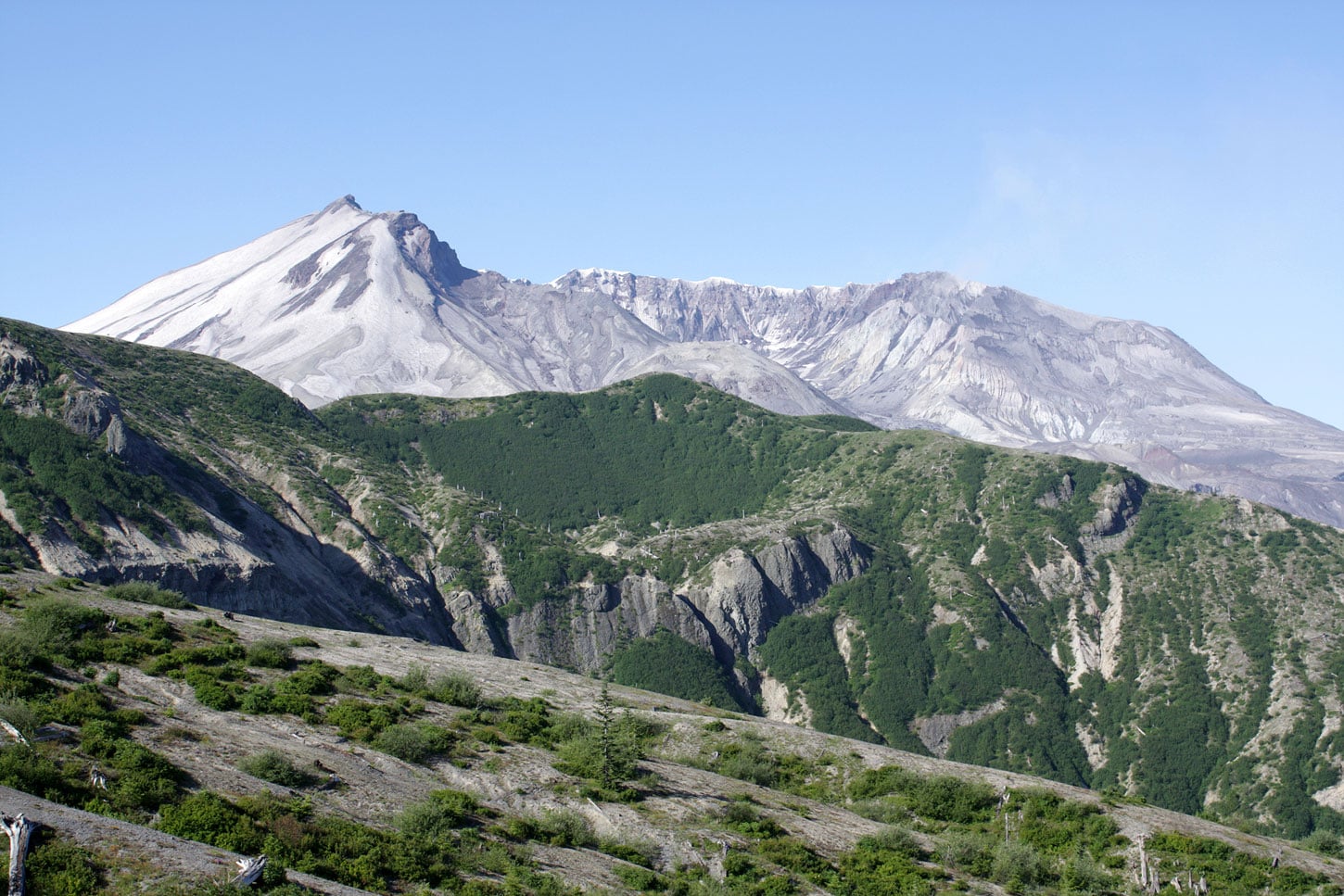
So what’s the deal? For starters, I’ve got my story wrong, even after all these years. “When Mount St. Helens erupted,” write Charles Goodrich, Kathleen Dean Moore, and Frederick J. Swanson in the introduction to In the Blast Zone: Catastrophe and Renewal on Mount St. Helens, “the story most people heard seemed to be almost entirely about violence, danger, and devastation.” Until my visit, I’d likewise only considered the violent aspects of the eruption. Actually, living down in the Sonoran desert and otherwise far from the Pacific Northwest, I’d hardly considered Mount St. Helens at all. Yet the Lady’s eruption is a part of our American landscape lore, even in my long-dormant volcanic landscape of the Southwest. Here I’m surrounded by the remnants of ancient activity. Just north of Tucson, for example, Picacho Peak rises an abrupt 1,500 feet from the desert floor, a geologic fault of tilted rock interlaced with rich veins of lava 22 million years old.

Photo by Simmons B. Buntin.
Fred Swanson, the fatherly guide for myself and a dozen other writers at the Pulse, knows something about the geology of volcanoes—he’s a research geologist with the U.S. Forest Service’s Pacific Northwest Research Station and is an authority on the ecology of Mount St. Helens. “Like a birder,” he says, “I have a life list of encounters with erupting volcanoes—walking across an advancing aa lava flow at Arenal in Costa Rica, feeling the heat of fountaining lava on the flanks of Kilauea, sensing the deep seismic rumblings of Fernandina, Galapagos. But nothing beats my continuing affair with Mount St. Helens.”
Mount St. Helens was my first active volcano, though not so volatile on this visit as it was even two or three years ago, when a new lava dome grew inside the broken, glacier-filled crater. Still, I could tell right away that she’s a lady worth pining over, especially on our sunny visit, when slopes of purple lupine and rivulets of Indian paintbrush ribboned her north side. Indeed, that first warm day on the Pumice Plain reminded me of the rare but glorious wildflower swaths of the desert in spring. Dazzling geometries of black and gray rock, crazy explosions of low-growing wildflowers in pink and lavender and red, dramatic vistas of mountain and sky at every turn.
Fred told us of his visits to the seared slopes of Mount St. Helens just days after the eruption: “My preconceptions of how volcanic landscapes behave in the aftermath of an eruption were blown away like the top of St. Helens, and I’ve been reconstructing my understanding ever since.” Almost right away the mountain’s re… is it re anything? He wouldn’t say recovered, surely? Renewed? Resurged? Resilienced? Regrown?
Life emerged rapidly, we might say. It returned, in a way, but mostly it already existed in tiny semblances here and there—protected from the blast by snowbanks, brought forth in new soil pushed up from surviving pocket gophers, dropped in on a spider’s floating web. The landscape’s repopulation wasn’t, as scientists originally expected, primarily from the edges of the blast zone inwards—though there was some of that, exemplified by the nesting horned larks and chicks we saw with the ornithologist Elise Larsen on our last full day on the mountain (the birds are not otherwise native to the region; the open, rocky expanse provides new opportunities). Rather, species recolonized the most impacted area—the Pumice Plain—through tiny oases of lupine communities that have, over 30 years, grown together not completely but still substantially. Meanwhile, a few silver firs, huckleberry, and willows have started to take hold.
Like Fred, renowned forest ecologist Jerry Franklin has also studied Mount St. Helens since the eruption; his research on the forest systems of the mountain began in 1959, in fact. Twenty-five years into his studies on the post-eruption landscape, he began questioning his use of the term recovery, “since implicit in the word is the notion of a return to some pre-existing condition,” he says. Coming from a background in forestry, he assumed like most others that it was both logical and natural for the mountain to return to its previously lush self. “[Yet] Mount St. Helens is not about ‘recovery’ to some future forested state,” he says. “It is about its natural evolution, its rich array of organisms and processes, and its contributions to our ecological understanding.”

Photo by Simmons B. Buntin.
Fred agrees: “The notion of ‘recovery’ may be relevant to specific components of an ecosystem in specific parts of the Mount St. Helens landscape. . . . But some parts of the landscape are new places on the face of the Earth—the crater, new lakes, and the debris avalanche deposit, which raised the land surface up to 600 feet in places. ‘Restoration’ and ‘recovery’ are not taking place there—these are wholly new ecological systems.”
Fred and Jerry were not the scientists with the fiery eyes, however. They’d dealt with artist types such as myself and knew that eventually I’d get it. And it wasn’t the job of the other scientists to convert me, either. It was really my task to connect with them and seek to understand, in a more generalist way, the application of their work to the mountain, to landscape renewal in general, and—in my particular case—to human communities.
So Mount St. Helens isn’t about recovery; can it still be about cultural significance? Is there a metaphor of resiliency for our built communities—post-natural disaster or otherwise—to be applied here?
On the first morning of our week-long residency, we visited a forest of silver fir where the mature trees survived the 1980 eruption. As we hiked beneath the deep canopy, I noticed the whitish stones, shaped like small river rock, that formed the trail and, I realized, covered the forest floor. I knelt to scoop a handful as a nearby researcher explained that the material is called tephra, which is large ash and pumice that falls from the sky as the volcano erupts. The soils of the Cascades are, I learned, comprised mostly of volcanic fallout including tephra, which during an eruption can range from less than a centimeter to a meter in depth. A two-centimeter depth doesn’t impact growing plants. At four centimeters, forest undergrowth such as herbs and huckleberry are harmed. More than 15 centimeters, and pretty much all small undergrowth is destroyed. Like ecosystems that rely on fire to return nutrients to the soils, however, volcanic ecosystems such as this silver fir forest, two thin valleys north of Mount St. Helens, rely on mineral-rich tephra soils.
On this first morning I also learned that Mount St. Helens is the tantrum-prone toddler of the Cascades chain of volcanoes, erupting on average every 150 years. Indeed, it’s one of North America’s youngest mountains: the base is perhaps 300,000 years old—what we see today, amazingly, is only 2,500 years old. And the symmetrical pre-eruption summit? Its shape was formed perhaps 20 or 30 years before the American Revolution.
Well before that, Native Americans called the mountain Loowit, and called its forests and lakes home. Archaeologists have surmised, however, that the area was abandoned for 1,900 years some 3,600 years ago. Why? There was a massive eruption, what’s called the “Y Blast,” that left tephra piled seven meters high where we then stood. An entire civilization displaced—an outcome as symbolic to the science of place, it seems to me, as to the culture of place.

Click image for larger view in PDF format.
Graphic courtesy U.S. Geological Survey.
Throughout the week, however, the conversations of the scientists largely excluded the role of humans. Whether measuring plant species in the silver fir forest or documenting nesting sites on the Pumice Plain, the only place for humans seemed to be in conducting the science itself: experts looking in—but not actually acknowledging mankind’s role in this rich landscape. Part of that is the nature of objective science, of course, but with such a methodical look at the natural systems, are human influences unduly factored out? Could it be that ecology is the study of natural systems absent of humans?
“Recovery!” I shouted. Or that’s what I would have yelled if I didn’t already know that the 2005 Pulse and other studies have considered the effects of past eruptions on traditional peoples across the region. Even the basest scientists would not disregard the symbiosis of humans and the natural world, would they? Without a doubt the natural world alters landscapes beyond comprehension, beyond time itself, but are we not learning that about mankind, as well? What landscapes have we not also altered significantly, if not irreparably?
And that’s where I seek more than just the metaphor of resurgence that Mount St. Helens and all disturbance ecosystems can be for mankind’s created places. What does this post-eruption landscape teach our built communities? What lessons can be learned from the striking resurgence of the landscape that, following the 1980 eruption, many believed would be barren for a century or more? What can the process of investigation in this post-disaster region mean for our villages, towns, and cities?
Over the next several months I plan to play the role of researcher myself, and though I may not find that answer, I will be able to follow these important questions, my own eyes burning, those beautiful, dirty words of science and community falling like tephra all around.
View Mount St. Helens Image Gallery.
Header photo by Simmons B. Buntin.