|
|
|
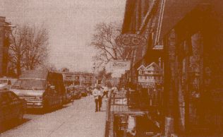
by Kent Stasiowski and Justin Hollander Newton Centre is a dense, mixed-use community located on a major mass transit artery within the City of Newton, a suburb of Boston first linked to transit—via the Boston and Albany Railroad—in 1830. The Centre is one of thirteen areas classified as village centers by the city. Though it wasn't until 1959 that public transit regularly served Newton, the community has continued to evolve. Newton was settled in 1630, but it wasn't until 1720, when residents erected a central meeting house, that Newton Centre was first recognized. The area was popular for mill development because of its proximity to the Charles River. Newton Centre remained a small village throughout the 1800s and into the early 1900s, when the main thoroughfare, Centre Street, housed "a provisions store, haberdashery, bank, and battery of public telephones," according to George M. Sanborn of the Massachusetts Bay Transportation Authority library in Boston. The area changed after World War I, when extensive redevelopment occurred, especially in the Centre's core. Second- and third-story apartments above retail were either removed or converted to office or additional retail space just after the war. "The Centre's center began to take on its current appearance in the 1950s, when the antiquated Mason School was torn down and replaced by a parking lot behind the common...," says Sanborn. "Then began what local merchants like to call the upgrading of the square, as stores were remodeled, more sophisticated customers arrived." Priscilla McQueen, a native of Newton Centre, believes the Centre still has "a village-like feeling, but maybe I've lived here too long." Sanborn points out, however, that others think Newton Centre has lost its village flavor as it has become more retail- and business-oriented.
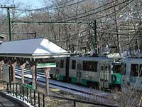
Newton Centre, compared to the Boston metropolitan area, is noticeably affluent. Only six percent of the population is below poverty level, while the average is 15 percent for the Boston metro area. The median household income in Newton Centre ranges from $52,000 to $82,000, as compared to $30,000 for metro Boston. The Newton Centre village of Newton is also largely homogenous, with 92 percent of the population white, as compared to 87 percent in the metro area. Transit and Land Use at Newton Centre Though many definitions of transit-oriented development include mixed-use development that follows the siting of a transit stop, Newton Centre as a community was around more than two hundred years before the MBTA light rail stop was constructed. Newton Centre can be classified as a transit-oriented development, however, based on the village's relationship to the stop, and based on the fact that the stop has both created and changed patterns of development and resident mobility patterns directly adjacent to the stop since its opening. The transit stop lies near the end of the Riverside "D" line in a primarily suburban region of Greater Boston. Bus service is on the "52" route that travels north-south above and below Newton Centre in the Newton area. The City of Newton also has a relatively new shuttle bus service providing service between the city's villages. The service connects the villages to existing MBTA bus and light rail stops. Additionally, Boston College runs buses through Newton Centre for its students, faculty, and staff. Light rail service is regular, running every five minutes during peak commuting times, and about every ten minutes at non-peak times. Bus service is less frequent, running every thirty minutes weekly, and up to every hour on weekends.
Ridership from Newton Centre averages just under 1,100 riders per day on the MBTA Green line. While there are peak commutes in the morning and evening, the valley of ridership between peaks is not as low in Newton Centre as in other nearby locations. Seventy percent of Newton Centre transit commuters walk to the transit stop, twelve percent park and ride, eleven percent are dropped off, and only seven percent take the bus. No riders indicated that they ride a bicycle to the transit stop. More than half of those who walk to the transit stop can do so in less than five minutes, and another forty percent in under fifteen minutes. A recent survey of transit riders arriving in Newton (though not necessarily Newton Centre) from other locales indicated that 41 percent arrive for work, twelve percent for personal business, and 3 percent for social or recreational purposes. Only six percent of riders indicated that they use Newton for shopping. While overall usage numbers for all types of trips is not available, U.S. Census Journey to Work data shows that Boston is the most frequent work destination for commuters coming from Newton Centre's transit stop. Newton is a distant second, and Cambridge is farther still in third. The data confirms the function of Newton Centre as a point of origin for Boston commuters, also affirming the transit-oriented development as a point of origin for residents who work in close proximity to their homes.
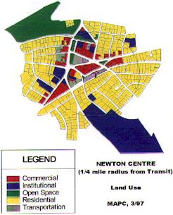
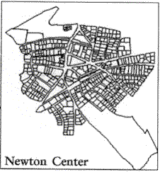
While the majority of Newton Centre residents do drive to work, it is significant that thirteen percent walk and fourteen percent take public transportation on a regular basis. Over a quarter of the residents, then, either use the centrally located transit or walk to their work destinations, an essential characteristic of a transit-oriented development. Of those who work in Newton Centre but live outside of the village, fourteen percent walk and nine percent use existing transit. Newton Centre's central core area is comprised primarily of retail and office uses intermingled with residences. Surrounding neighborhoods are comprised largely of residences, small retail, and large institutions. Residential uses make up over 3.3 million square feet, while commercial is over 582,000 square feet. Of the commercial square footage, retail comprises over half, office over 30 percent, and restaurant uses the remaining share. Newton Centre's retail shops serve as a destination for many, though are not a large draw for those outside of Newton itself according to studies by the city's Economic Development Commission. In fact, the Newton Centre Merchants Association is working to change the character of the Centre from a commuter point of origin to a commercial destination. The Association does not necessarily see eye-to-eye with proponents of reduced automobile use and increased transit, viewing parking spaces as the keys to local commercial success. The Association does not believe the transit stop is a significant enough mode of transportation for incoming retail and other users. Newton Centre as a Transit-Oriented Development There are seven primary characteristics of a transit-oriented development exhibited by Newton Centre: An aerial view of Newton Centre reveals that most of the major streets connect in a grid-like fashion. Of the 28 streets in a 1/4-mile radius around the MBTA light rail stop, only three end in a cul-de-sac or dead end. Local Destinations Within Walking Distance Within the 1/4-mile distance around the transit stop, there are schools, places of workshop, community service centers, daycare facilities, six green space and park areas, residences, and numerous shops, restaurants, and offices. Three educational institutions border Newton Centre, and one mile north of the transit stop is the Boston College School of Law. Pedestrian-Friendly Design Newton Centre's continuous sidewalk system creates safe and convenient routes for pedestrians. The sidewalks on residential streets are wide enough for two people to walk abreast, and in the core areas the sidewalks can accommodate four or more abreast, measuring between six and ten feet wide. Other aspects of design welcoming pedestrians include mature street trees and other landscaping, on-street parking, streetscaping with street furniture, and highly visible pedestrian crosswalks. At high-volume intersections, for example, raised or otherwise more visible crosswalks have been established where traffic must stop if a pedestrian is in or nearing the crosswalk. Topography Suitable for Walking The topography of Newton Centre is varied. In the central commercial core adjacent to the MBTA transit stop, the land is primarily flat. There are small hills in the northwestern residential neighborhoods, but these do not present a reported problem for elderly, young, or disabled. Density and Pedestrian Scale The street layout of Newton Centre is not a typical grid. The formation of the streets over time created fairly large blocks and relatively infrequent intersections. However, less grid-like intersections tend to have a strong orientation for the pedestrian: many of these intersections neck-down to make them easier to cross. In the central commercial core, the largest block is approximately 500 feet by 380 feet. The distance between intersections in the residential neighborhoods, for comparison, is even greater, up to 800 feet. The density is high enough to support transit, but does not manifest itself into large office towers or apartment buildings. Most commercial space is housed in one- or two-story buildings on small parcels in the central commercial core. The average building's footprint is about 5,800 square feet, with the largest at 51,500 square feet. Most of the larger buildings use architectural elements to break down the facade into the appearance of even smaller buildings. They feature pedestrian-scaled windows, overhangs, awnings, recessed entryways, attractive signage, and the like. Residences are generally of a medium density, and predominantly single-family homes. There are a fair amount of duplexes and multiple-family dwellings, however. The largest apartment building is three stories with 50 units, but such buildings are rare.
Street Facing Buildings and Rear Parking Buildings face the street and parking is reserved for the rear—with the exception of on-street parking—for all buildings adjacent to the transit stop and in the core commercial center. Most residential streets also maintain an inviting character, with the buildings facing the street and garages on alleys or driveways to the sides of houses with garages in the rear. Many businesses share parking, clearly marking parking lots with signage, create clear walkways within the lots so that customers can easily and safely walk between the lots and the stores, and maintain an attractive rear facade. The rear lots are either public metered, private, or shared private. Shared private lots are shared between businesses that operate at different business hours, such as a lot reserved for a drugstore and bank during the day, and restaurants at night. Large signs direct motorists to public and private lots throughout Newton Centre, but these are secondary to pedestrian routes among streets, buildings, and the transit stop.
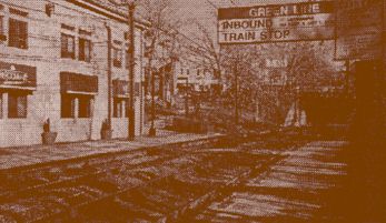
Transit Stops Accessible by Foot The centrally located MBTA light rail stop is easily accessible for the approximately 2,000 households in the 1/4-mile radius. There are pedestrian bridges, pathways, and ramps that offer easy access to the transit stop for those traveling by foot. Additionally, there are bus stops located even closer to the central commercial core, where Centre, Beacon, and Cypress Streets intersect. The stops are across the street from each other, but wide sidewalks, crosswalks, and pedestrian-friendly street design allow access for all abilities of pedestrians. For riders arriving at the MBTA stop via car, there is a limited number of parking spaces. The transit stop serves as a commuter hub in the morning and evening. Restaurants and retail shops cater to commuters, offering food and drink, newspapers and magazines, and other items ideal for the person on the go. The walkways are safe in and adjacent to the transit stop, and indeed the whole area is active from early in the morning to late in the evening, helping to ensure that crime is not a major concern. Conclusion The challenge of maintaining Newton Centre as a viable transit-oriented development is constant. While commuting ridership is virtually guaranteed, ridership will need to change if the transit stop is to serve the purpose of bringing additional shoppers, and their money, into the commercial core, as well. That will likely require the vested interest of local business and political leaders as well as involvement from regional entities, including MBTA. But as the village's history has proven, the core area so far has always been supported by rail, first heavy and then light. Newton Centre residents and visitors have every reason to believe that the light rail stop and adjacent uses will support the village center as a transit-oriented development far into the future.
|
|
||||||||||||||||||||||||||||||||||||||||||||||||||||||||||||||
 Today, the City of Newton's total land area is 18.1 square miles, with a population of 83,000. In Newton Centre, there are over 2,700 households with a population of nearly 8,000 people. Within the 1/4-mile radius around the Massachusetts Bay Transportation Authority light rail stop (Newton Centre "T" stop, Riverside Branch, on the east-west Green line) there are nearly 600 dwelling units at a density of 7.4 units per acre. According to 1990 Census figures, there are 1.81 autos available per household in Newton Centre, which is higher than the 1.46 for the Boston metropolitan area, but lower than most suburban locations. Only 60 percent of the MBTA transit riders living in Newton Centre, however, have access to an automobile.

 Interconnected Street System