|
|
|
By Tom Leskiw
Long before the concept of political borders emerged, human and wildlife movement was tied to natural borders: desert and oasis, oak woodland and grassland, forest and brush field. Mountain ranges—later termed “sky islands”—were linked to valley “seas” of grass and brush by the riparian corridors of the Santa Cruz, San Pedro, and Rio Grande Rivers. The health of the landscape depended upon connectivity and movement—of birds and creatures such as coyote as agents of seed dispersal, of fire to periodically cleanse the grasslands of competing vegetation, of fish migrating upstream or down in search of more favorable conditions, and of water, to transport and deliver wood, sediment, and nutrients. For millennia, these peregrinations continued unabated—as evidenced by the presence of palm trees at isolated oases and human trails worn a foot deep along the path used to procure salt from the Gulf of California. Today, the media portray trans-border movements as a one-way highway, always northward. However, a substantial number of Catholics on the U.S. side still make a yearly pilgrimage to the old mission community of Magdalena de Kino, some sixty miles south of the Arizona-Sonora border, for the Fiesta de San Francisco. In 1854, the Gadsden Purchase was ratified by the U.S. Senate. It included lands south of the Gila River in Arizona and in southern New Mexico. The revision of the U.S.-Mexico border was part of the negotiations needed to finalize issues that remained unresolved from the Treaty of Guadalupe-Hidalgo, which ended the Mexican-American War of 1846-1848. For a number of years, the newly drawn political boundary affected neither the movement of wildlife nor that of borderland residents. Indeed, as recently as 1930, some members of the Tohono O’odham—formerly known as Papago—had no knowledge of the redrawing of the boundary and believed they lived in Mexico. With the opening of the West, however, came railroads, vast water reclamation projects, roads, and utility lines. Since then, the overarching theme of Southwestern settlement has been the elimination or degradation of the connectivity so vital for the health of ecosystems and their denizens. Half of southern Arizona was formerly grassland. Historically, the U.S. Forest Service encouraged overgrazing to reduce grass, which carried ground fire. As a result, the current boundaries of vegetative communities—mesquite, introduced grasses, and tamarisk—bear little resemblance to historical distribution. Livestock fences also cut upon traditional migration routes of wildlife, including pronghorn antelope, javelina, and bison. Predators like the Mexican wolf were extirpated while populations of jaguars, ocelots, and jaguarundis were reduced or eliminated from the Southwest. Conservationist Aldo Leopold, an avid wolf hunter early in his career, grew to realize that “[o]ne of the penalties of an ecological education is that one lives alone in a world of wounds.”
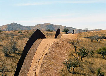
Overuse of ground and surface water adversely impacted water courses, springs, and riparian vegetation, resulting in population declines for many of the 80 percent of vertebrate species in the borderlands region dependent on streamside areas for at least part of their life cycle. The wounds inflicted upon aquatic resources were noted by Leopold in 1937: “Somehow the watercourse is to dry country what the face is to human beauty. Mutilate it and the whole is gone.” In the wake of 9/11, the security of the United States’ borders has come under increasing scrutiny. Owing to the influx of undocumented workers from Mexico, one “solution” now under implementation is the construction of a wall along our southern border. In 2006 Congress, in response to a national outcry about our porous border, approved the Secure Fence Act. The law authorized the U.S. Department of Homeland Security to construct 845 miles of double-layered fencing along the southern U.S. border, which spans nearly 2,000 miles. The wall carries a price tag of $49 billion for construction and 20 years of maintenance. Impact from the wall is exacerbated by associated infrastructure: access roads, cameras, sensors, and stadium-style lighting in some locations. Not only is the wall the latest in a long series of actions severing the connectivity between wildlife and its habitat, but it also bisects some of the most biologically rich areas in the U.S. Opponents of the wall have voiced a number of concerns, which include:
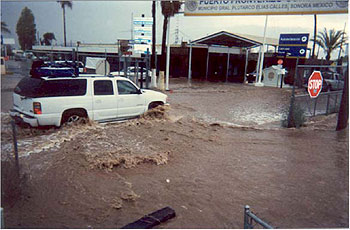
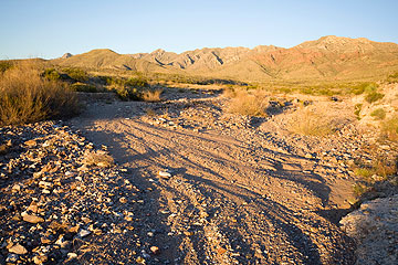
The following four case studies examine impacts—hydrologic, biologic, cultural, and economic—from four segments of the wall’s construction, as one would encounter them, west to east: Case Study: Organ Pipe National Monument, Arizona In 2006, DHS proposed the construction of a 5.2-mile-long fence in Organ Pipe Cactus National Monument, along the U.S.-Mexico border. Comments in the Draft Environmental Assessment included concerns that the structure could impede floodwaters and that debris could be trapped by the wall, leading to backwater pooling and lateral flow that would damage the Border Patrol road and other infrastructure in both the U.S. and Mexico. The response to these concerns in the Final EA and Finding of No Significant Impact was that “the wall would be …designed and constructed to ensure proper conveyance of floodwaters and to eliminate the potential to cause backwater flooding on either side of the U.S.-Mexico border.” In addition, Kiewit Western Co., the contractor building the fence, furnished a handout that stated the design (6-inch x 24-inch openings in the wall where it crossed drainages) would “permit water and debris to flow freely and not allow ponding on either side of the border” because the drainage crossing grates “met hydraulic modeling requirements.” The wall, finished two weeks prior, received its first test during a July 12, 2008 storm, where one to two inches of rain fell in 90 minutes. Fine and coarse sediment and debris plugged the grates in least five arroyos, creating stream diversions (lateral movement of water beyond their respective floodplains) ranging from 100 feet to 1,110 feet. Headwaters Wash flowed over 200 feet to the east along the wall and through the international port of entry at Sonoyta, Sonora, Mexico. Floodwaters damaged private property, government offices, and commercial businesses in Lukeville, Arizona, and Sonoyta, Sonora.
Concerns voiced by the wall’s opponents proved to be well-founded, as the rainfall received on July 12 was not unusual; statistically, it is estimated to occur at least once every three years. Based on precipitation records that span 60 years at Organ Pipe, the rainfall intensity experienced on July 12 occurs every:
Case Study: Nogales, Arizona
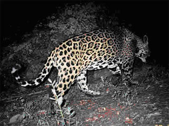
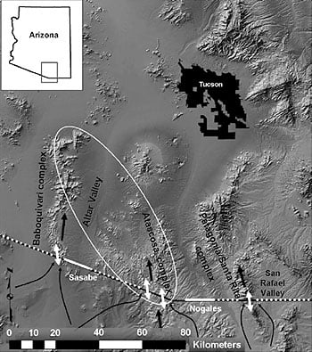
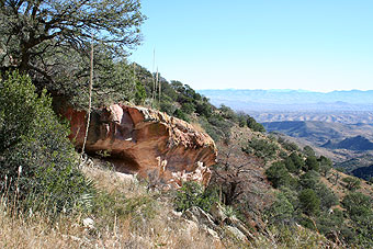
The Atascosa Mountains lie just northwest of the border town of Nogales, about 70 miles south of Tucson. I’m among those that were surprised to learn that a wildlife study has documented the presence of two jaguars in the area. An adult male jaguar, dubbed Macho B, was photographed north of the border for over 11 years, and he resided in Arizona continuously and year-round from 2004-2007. A jaguar named Macho A was also photographed during this time frame in the same study area. Analysis of spot patterns confirms that at least four jaguars have been recently photographed in the Southwest, as the jaguar in extreme southeastern Arizona in 1996 and the one photographed February 2006 in the Animas Mountains of southwestern New Mexico are different individuals. Policy changes in the 1960s and 1970s led to a sudden decrease in jaguar reports in this region. In 1969 it became illegal to kill jaguars. Establishment of the Endangered Species Act in 1972 resulted in fear of federal restrictions on private property and general animosity toward endangered or threatened species. Put simply, the sudden decrease in jaguar reports gave the false impression that they’d disappeared from the Southwest.
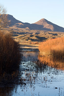
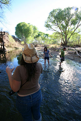
The conservation of wildlife populations at the periphery of their range is now considered extremely important to the long-term survival of endangered species. The preservation of sufficient core and connective habitats to avoid population fragmentation is seen as crucial to reducing the probability of extinction for species such as jaguar. Therefore, the construction of a nine to 15-foot-high fence across approximately 70 percent of the Arizona border does not bode well for the small, northernmost population of jaguars, as it will isolate them from the larger source population in northwestern Mexico. Case Study: San Pedro River, Arizona The San Pedro River is unique because it flows south-north across the border, connecting the ecologies of the tropics and the Sierra Madre Mountains with those of the far north. Biologists estimate that 400 bird species, 83 mammal species, and 47 amphibian and reptile species inhabit the San Pedro, the longest undammed river in Arizona. The San Pedro was the first site in the Western Hemisphere to be designated as an Important Bird Area by the American Bird Conservancy. It hosts some 4 million migrating songbirds each year. Ten percent of the roughly 530 species on the federal endangered species list can be found along the San Pedro. It is home to more mammal species—including jaguar, coati mundi, and javelina—than any place on Earth, except Costa Rica. The cottonwood-willow forests that were once common along Southwestern rivers have been greatly impacted relative to pre-settlement conditions.
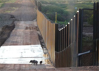
In the late 1800s, fur trappers removed an estimated one million beaver from the San Pedro watershed. The extirpation of beaver—a keystone species—in 1900 was especially devastating to the watershed, as their dam-building had reduced the river’s erosive power. The resulting stair-stepping watercourse buffered the watershed during seasonal floods. Large pools spread the water outward, fostering a network of wetlands that were effective in recharging ground water. The devastated rangeland, shorn of grasses by too many horses and cows, had lost its ability to hold soil in place when a multi-year drought ended and the rains returned in 1893. The once stable, slow-moving, marshy perennial river transformed into an unstable, flood-prone, intermittent stream. Stream downcutting largely eliminated the wetlands, resulting in a lowering of the water table. In 1870, Arizona rancher H.C. Hooker had described the San Pedro River Valley as “having an abundance of timber with large beds of sacaton and grama grasses. The river bed was shallow and grassy … its banks with luxuriant growth of vegetation.” His description of the same area in 1900 told a different story: “The river had cut ten to 40 feet below its banks with its trees and underbrush gone, with the mesas grazed by thousands of horses and cattle.” Recognizing the importance of beaver to watershed health, the U.S. Bureau of Land Management reintroduced them to the San Pedro in 1999. More than 350,000 people travel to Arizona annually to view birds. They Opponents of the wall voiced concerns regarding its construction across the San Pedro River, its floodplain, and over 60 seasonal streams and desert washes in the vicinity. In late 2008, the U.S. Army Corps of Engineers constructed a “temporary” vehicle barrier across the San Pedro. This new placement follows roughly two miles of fence already existing within the San Pedro Riparian National Conservation Area. Project photos depict a Normandy-type beach fence that cuts across the river bed and an access road that has been graded to the river’s edge.
Opponents question whether federal officials will be able to remove the barriers, as promised, during high-water periods such as the monsoon season. BLM managers have little power in light of the waiver of environmental laws for the wall’s construction. The Borderlands Conservation and Security Act of 2007 (H.R. 2593), sponsored by Rep. Raul Grijalva (D-AZ), sought to force DHS to create a strategy that had the dual goals of securing the border while best protecting public forest and park lands along it. The bill never became law and, because it was introduced in a previous session of Congress, no more action can be taken. Case Study: Lower Rio Grande Valley, Texas Four climatic zones converge in south Texas, and the U.S. Fish and Wildlife Service has identified 11 distinct habitats in the lower Rio Grande Valley. More wild cats—ocelots, jaguars, and jaguarundis—live here than anywhere else in the United States. Because of the Rio Grande River’s sinuosity and the need to construct straight fences, some segments of the wall are slated to be constructed 2 .5 miles from the river—in effect, ceding to Mexico portions of prime wildlife habitat that include the Lower Rio Grande Valley National Wildlife Refuge and the Audubon Society’s Sabal Palm Preserve. In late December 2008, a property owner in the Lower Rio Grande Valley received notice that DHS had filed suit to condemn a portion of the property. The complaint stated that the amount of $114,000 offered by DHS was deemed “just compensation” for the slightly more than 8 acres the 18-foot-tall, concrete-and-steel barrier wall will occupy—a 60-foot-wide strip of land slated to cross 6,000 feet of the landowner’s property. The owner felt that the amount offered was grossly insufficient compensation for a property purchased in 1999 for $2.6 million. The fence, slated to be constructed 1.5 miles from the Rio Grande River would, in effect, cede more than 700 of the 1,034-acre property to Mexico. Most importantly, the full-time caretaker’s residence and all the property’s facilities are located on what is to become Mexico’s side of the wall. The Nature Conservancy owns the subject property: the Lennox Foundation Southmost Preserve. The site harbors a native plant nursery that supplies reforestation projects throughout South Texas, a compatible agriculture demonstration, a rare sabal palm forest, and habitat for Texas’ highly imperiled wildcats, the ocelot and jaguarundi.
The preserve also serves as a living laboratory for university students and researchers from various parts of the country who spend periods of time living on the property while they study its unusual birds and amphibians. Despite repeated requests to the DHS for information about access and safety issues that will arise once the fence is built, Conservancy staff have not received a response. The wall’s opponents fear that its construction will serve to isolate wide-ranging species in nonviable habitat islands. As Michael Soule and John Terborgh have written, “Connectivity is not just another goal of conservation: it is the natural state of things.” Furthermore, owing to the impacts of global warming, the preservation of migration corridors is critical so that species can adapt to changing climatic conditions. There is also an environmental justice aspect to the wall’s construction. The Texas Observer reported that in south Texas, the wall will end abruptly at Sharyland Plantation, a 6,000-acre gated golf community owned by Dallas billionaire Ray L. Hunt, a close friend of George W. Bush, who donated $35 million to help build Bush’s presidential library. As of February 2009, 601 miles of the 845-mile wall have been completed at a cost ranging from $200,000 to $15 million per mile. DHS has admitted—albeit obliquely—that its waiver of nearly 40 laws to expedite construction has come at a price to the environment. DHS has since given $90 million to the U.S. Department of the Interior to restore wildlife habitat and cultural sites damaged by construction and maintenance.
Property owners who’ve resisted the construction of the wall across their property have found themselves subjected to condemnation lawsuits filed by the U.S. Government. The terms and conditions of these legal rulings are onerous: the government need only pay for the land on which the barrier sits, regardless of how much property winds up inaccessible or uninhabitable. Eloisa Tamez, for example, is a 72-year-old woman who still lives on a portion of the 12,000 acres her ancestors received in a Spanish land grant. In the 1930s, the federal government condemned more than half her holdings to build levees—she still has not received compensation. In August 2007, a U.S. Border Patrol agent told Tamez her land was in the path of the proposed wall and that she needed to sign a release form so engineers could survey her land. She refused to sign the paperwork, her courage inspiring 300 other Texan property owners—political progressives and property rights advocates alike—to do the same. Tamez received less than $14,000 for the wall that now bisects her property. Similarly, on Leonard and Debbie Loop’s 1,000-acre farm, 800 of its acres will be exiled to the “Mexican” side of the wall. During his February 21, 2008 debate with Hillary Clinton, candidate Barack Obama stated that the wall was ineffective and counter-productive. He later pledged to evaluate whether or not to continue the wall’s construction in the Lower Rio Grande Valley. Opponents of the wall had hoped that once President Barack Obama took office, plans to build fencing along the Rio Grande Valley's wildlife corridor would be suspended. However, an Obama spokesperson recently told TIME magazine that the president supports the fence “as long as it is one part of a larger strategy on border security that includes more boots on the ground and increased use of technology.” In January 2009, the government allocated an additional $50 million for wildlife mitigation. According to Rick Schultz, the U.S. Department of the Interior's national borderland coordinator, it will likely be spent in the lower Rio Grande Valley to restore or recreate the habitats of native species. But there’s a catch: the mitigation efforts must compensate for the impacts to resources “managed, protected, or under the jurisdiction of the Department of the Interior,” according to federal documents. That stipulation excludes Brownsville area sites that are privately owned, such as Sabal Palm and Southmost Preserve.
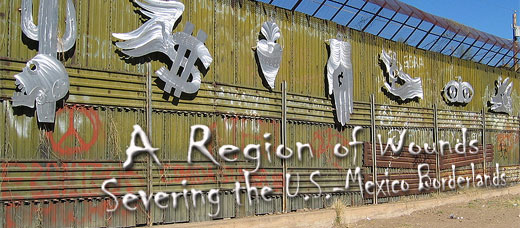
Chicana poet and activist Gloria Anzaldua characterized the U.S.-Mexico borderland as “una herida abierta”—an open wound. Clearly, the issues associated with our borderlands are murky, tangled, complex. Illegal immigration is an issue that needs a solution. The question is: Are we seeking appropriate, valid solutions—ones that minimize impacts to irreplaceable natural and cultural resources? As former Arizona governor and current DHS Secretary Janet Napolitano has stated, “The voters of my state understand that building a fence is not a solution. Indeed, what I'm fond of saying is, you show me a 12-foot fence and I'll show you a 13-foot ladder.” What are taxpayers to make of a project initially estimated to cost $49 billion, and plagued with huge cost overruns, for which one of its chief proponents, former DHS Secretary Michael Chertoff, admitted in 2007, “The idea that we are going to solve the problem by simply building a fence is undercut by the fact that yesterday we discovered a tunnel. So the idea that fencing alone is a solution I think is overly simplistic.” History is full of examples where ideology trumped a more carefully considered course of action… and reason. Clues—metaphorical breadcrumbs left by our forefathers to help us find the way—are there for those who wish to follow the advice of Socrates “to lead an examined life.” Opponents of the wall near Lukeville, Arizona, were assured that it would not allow ponding on either side of the border because the drainage crossing grates “met hydraulic modeling requirements.” And yet the wall failed catastrophically during its first rainy season. Does this not underscore the need for fresh models, literally and figuratively? For decades, south Texas wildlife proponents have worked to turn fragmented habitat at sites that include the Sabal Palm Audubon Center, Bentsen-Rio Grande Valley State Park, Lower Rio Grande National Wildlife Refuge, and the Lennox Foundation Southmost Preserve into an interconnected whole by maintaining wildlife corridors between the sites. The construction of the wall is a giant leap backwards, severing the string of pearls— and their attendant biodiversity.
The future looks increasingly murky. Border wall stadium-style floodlights are disorienting the migration of birds, bats, and butterflies. Are we bequeathing a world where our offspring will be able to see jaguars and ocelots—if only for an instant in the shadows of dense cover? Will beaver continue to ply the waters of the Southwest, their dams slowing the awesome force of runoff from mid-summer thunderstorms? Are we up to the challenge of water conservation and reuse—so that trout, beaver, and all aquatic organisms can find refuge during times of drought?
Comments are closed.
|
|
||||||||||||||||||||||||||||||||||||||||||||||||||||||||||||||||||||||||||||||||||||||||||||||||||||||||||||||||||||||||||||||||||||||||