|
|
|
by Wendy Call Benedín García climbed easily up the west pyramid, the highest in the “Complex-A” ruins. Not fully excavated, the front of each ancient Maya building emerges in fuzzy brown, round-edged rock from the vegetation that once hid it completely. Its back melts into a hillside of humus and fern. Fifteen hundred years ago, the people of Uaxactún (pronounced “wah-shock-TUNE”) had buried their king in the temple under Benedín’s feet. Beside their deceased leader, they had laid jade necklaces and earlobe plugs, jaguar teeth, copal incense, pearls, pottery, seashells, and a single sting ray spine, painted red. Benedín waved to me, far below him on the forest floor. He yelled that he could see all the way to his village, even past it, to the community forestry site. Benedín stood on the west temple of the complex, one of seven ruins in the village of 138 families in Petén, Guatemala. The northern half of Petén has been protected since 1990 by the Maya Biosphere Reserve, the largest swath of lowland rainforest north of the Amazon basin. The reserve was intended to stop timber companies, farmers, and ranchers from cutting down the trees. From where Benedín stood, balancing casually on the stone temple’s apex, he could see Complex-B to the north. To the east lay the airstrip built half a century ago, when Wrigley’s planes flew in regularly to buy chicle tree resin. Planes no longer land there; villagers graze horses on the long, bare rectangle. It has become the village center, surrounded by small stone, bamboo and cement buildings. I sat on a stray stone next to Complex A’s west temple. In the famous Maya forest around the ruins, hundreds of insect wings rasped together into a single tone. The leaves of the mahogany trees rustled like parchment pages. I suddenly understood why forests are often compared to cathedrals: thousands of beings are forever present, bearing witness. In the Maya forest, the rare ocellated turkey cocks its head from side to side, as if preening. It isn’t looking at its own green, purple and bronze plumage, but at its surroundings. Its iridescent feathers reflect any movement. The howler monkeys, so unfairly named, sing their safety as a baritone hymn. They howl during the day only when they aren’t hunted, falling silent when threatened. Vines thick as church-bell ropes hang down from far overhead, undulating in the breeze.
Like most Uaxactún residents, Benedín is neither indigenous Maya nor Petén-born. He comes from a town called “Holy Spirit,” in the southern Guatemalan department called “Progress.” He arrived in Uaxactún 42 years ago with his brother Salvador, when both were teenagers. There were no roads to Petén at that time. Salvador and Benedín came by plane from Guatemala City to Flores, Petén’s regional capital. From Flores, they flew to Uaxactún, 28 miles north, for five quetzales. Had they looked out the window half-way through that flight, they would have seen the region’s most famous ruins, Tikal, just beginning to be excavated. For me, the Maya forest marked the last stop on a two-year journey. From 2000 to 2002, I visited rural, indigenous communities in southern Mexico, Guatemala, and Nicaragua. Two questions drove me: What are the alternatives to our society’s excessive consumption? In our mobile society, how does one find home—become native to a place? These questions are two sides of the same coin, at least in the currency of “bioregional” thought. Based on the limits marked by local climate, biota, and watersheds, “bioregions” are the physical boundaries of ecosystems. Bioregionalists, taking these local regions to be the contours of home, believe that cultures and economies should be scaled to the home region, with people relying primarily on local resources. Others have come to Uaxactún looking for something similar. Salvador and Benedín left their parents behind to live with an aunt in Uaxactún. “If we had ended up somewhere else, maybe we would be farming. South of here, because of the ranching and farming, the forests are really threatened,” Salvador says. “You’ll see pasturelands, areas made into wasteland by cornfields. But here in Uaxactún, it’s different. We’ve taken care of the forest because we depend on it…. I’ve learned how to survive from the forest. I’m really thankful to the first people who learned how to survive this way. They have taught us how to live.”
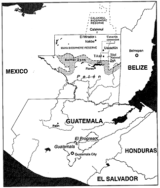
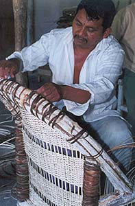
The Maya forest that surrounds Salvador’s home spans three nations: Belize, Guatemala, and Mexico. The political boundaries, mere abstractions, should be invisible. On satellite images, though, much of the line between Petén and Chiapas, Tabasco and Campeche is a stark slash between Guatemalan forest and Mexican bare earth. When I looked at the forest around the Complex-A ruins, I saw Uaxactún’s entire economy: deep green xate (pronounced SHAH-teh) palms with pendulous, green and white fruit; red-barked chicozapote trees criss-crossed with machete wounds; tall, black-stemmed pepper plants, thin as reeds; and mahogany trees, trunks splaying out into brawny buttresses. Nearly all the villagers draw their livelihoods from the forest, but only a few from the trees. They collect deep green xate palm leaves for floral arrangements in wealthy countries. They harvest the pepper plant’s seed pods: allspice. They drain chicle sap from the chicozapote trees. They cut down just a few of the mahogany trees, using both trunk and branches, leaving the twigs and leaves to fertilize the forest floor. They cut the vines that hang down from the trees and weave them into wicker furniture sold in Guatemala’s tourist meccas. Each harvest demands careful balance. Cut the xate frond in the wrong place, the plant dies. Bend the pepper plant too far, the stem breaks. Slide a machete blade too deeply into the chicozapote bark, insects invade and destroy. Fell too many large trees, in floods too much heat and light. Much of the forest floor’s life withers without the essential, dim dampness provided by the canopy. In 1964, the population of Petén was just over 25,000 people. By 1996, it had ballooned to more than half a million. In the mid-1990s, while the population of Guatemala grew at 2.9 percent annually, Petén’s population grew 10 percent each year. This is due mostly to migration, but also to Petén’s birthrate. At around 7.0, it’s one the Latin America’s highest. Uaxactún’s 138 families are responsible for 206,390 acres of land, 98% of it forested. That’s nearly 1,500 acres per family, though the people of Uaxactún don’t see it that way. On January 12, 2000, the Guatemalan government’s National Council of Protected Areas (CONAP, for its Spanish initials) sold a 25-year, limited harvesting concession to the community of Uaxactún. “The government finally put in some controls, and then it gave concessions to the communities.” Salvador says simply. The logging companies left. “Now each community does the harvesting.” The villagers must account for every tree felled, every kilogram of allspice harvested, every bundle of xate loaded onto a truck. Salvador’s casual explanation sums up many years of struggle by Uaxactún residents and international environmental organizations.
One element of their success: after much negotiation, CONAP agreed to charge them less than half what it charges corporations to harvest Petén trees. It’s a bargain for CONAP. In exchange for the reduced fee. Uaxactún’s villagers monitor poaching on their lands. It would be impossible to completely eliminate illegal activity. Still, the village seems to do a better job than the government – which devotes only 80 cents per acre per year to nature reserve protection. Just a few days before my visit, villagers had come across a poachers’ encampment and insisted they leave. Salvador planned to return to the site the following week, to make sure they had left. According to a 1995 satellite map of the Maya Biosphere Reserve, Uaxactún had lost no forest cover in the previous decade, while illegal loggers had damaged every national park that had roads. Of course, that was before the concession was granted. Does the concession work? A review from the Guatemala office of the environmental organization ParksWatch has concluded it’s too early to answer that question. I asked Erik Cuellar, director of concessions for CONAP, whether the harvesting might be unsustainable. He replied that it “could be,” but “there is no alternative.” Although no one knows whether the concessions truly represent sustainable forest use, CONAP has granted them to 14 villages and community associations throughout the biosphere reserve. None of the other concessions approach the size of Uaxactún’s. “At first they said we were crazy—why did we want so much land?” Benedín says. He knew the community needed it to maintain control. He and Salvador have visited other communities in northern Guatemala, and seen how their conservation efforts have been undermined by neighbors and outsiders who don’t share their values. Some of those places have been left as tiny islands of green in a wide swath of brown. Still, Erik Cueller calls people like the García brothers “extreme conservationists.” Threats loom over the Petén forest. In 1970, an oil company first built a road from Tikal to Uaxactún. Because the road was there, loggers came. My first afternoon in Uaxactún, I joined Salvador and Benedín at a meeting with the village president, Rocael Peña, and other community leaders. Forty minutes into our discussion, the subject of the highway first arose. Benedín introduced it this way: “This is what all of us fear.” I asked him why. “It will be the end of us,” was all he said. Salvador finished his brother’s thought, as he sometimes does. “It’s going to leave our forest in pieces. Did we save all this to have others come with their big machinery?”
“It would be a complete change from the life we have,” Rocael added. When the dirt road first connected Uaxactún to Flores, things got better and worse for the villagers. They could come and go more easily, as could the products they bought and sold. The road also brought more people cutting down trees, hunting wild animals, leaving behind trash. Those people are the problem, according to Salvador. Though he, Benedín, and Rocael are all immigrants to Uaxacatún, they have made it their home. “Because he hasn’t struggled, because he has nothing, the migrant comes only to disturb, to be a predator,” Salvador says. “Not us. If we cut a tree, it’s because we need it. We’re not going to waste the forest.” Salvador, like most of his neighbors in Uaxactún, thinks small-scale and low-impact—two central elements of bioregionalism. The community leaders try to make decisions considering both economic development and environmental sustainability. Villagers have watched engineers pass through Uaxactún on their way north to Río Azul, part of the biosphere reserve’s central core. Salvador sees the forest as an integrated whole. The road makes no sense to him. Bits of the forest can’t be sliced off—much less removed from the middle—without damaging the larger organism. “After they have given us a concession for 25 years, they can’t give someone else a concession!” he insisted at the community leaders’ meeting. “We only have the right to harvest from the forest. It’s not our private property,” Rocael replied. He explained to me that the community has held several meetings to discuss the highway. “Most are afraid of it, but some say it will bring new employment.” The dirt road has fallen into such disrepair, heavy rains leave it impassable. “If the idea is to help us, why don’t they rebuild the dirt road?” Salvador wondered.
Numerous highway plans for Petén have surfaced over the last couple of decades. In the most common proposal, the pavement would slice through the forest north from Tikal, passing through Uaxactún, across the Guatemala-Mexico border, to the Calakmul nature reserve. Calakmul is already connected by highway to Cancún. The idea is to lure Cancún beachgoers to the Tikal ruins. Fifteen years ago, the World Conservation Union proposed the Tikal-Calakmul route, along with several others, at a conference entitled Tourism: A Vital Force for Peace. Though little happened with the proposal, the same route showed up in Mexican government plans a decade later. In 1995, the World Bank recommended that “a complete moratorium on road improvement should be imposed [and] public road maintenance should be limited” throughout Petén. Recently, the highway idea has risen again, as part of monstrous industrial development program proposed by the Inter-American Development Bank. The Plan Puebla Panama proposes, among other things, an extensive new network of highways through southern Mexico and Central America. The Guatemalan government urged the Tikal-Calakmul route be included in the plan. The Inter-American Development Bank said no, as its internal guidelines prohibit funding highways in nature reserves. Nonetheless, the plan seems to persist under other auspices; early this year Uaxactún residents saw construction equipment pass through their village. When I asked the Uaxactún leaders about other challenges facing the community, their first reply was: Richard Hansen. He is the latest Mormon archeologist to come to Mesoamerica in search of the lost tribe of Mormon predecessors, the “Nephites.” (Yes, it’s true. Read “This is Not the Place,” Hampton Sides, DoubleTake, Spring 1999.) Hansen is excavating Nakbe—the largest Maya ruin in Guatemala, in the heart of the biosphere reserve north of Uaxactún. He is also raising money for the “Mirador Basin” project, a large-scale tourist operation that would redraw national park boundaries in the region, leaving a chunk of forest with much less protection. He plans to fly in well-heeled tourists by helicopter, piggybacking on Tikal’s popularity. Two months before my visit to Uaxactún, Hansen had come to the village to discuss his plans, but the village leaders weren’t interested in what he had to say. For them, “heli-tourists” would be a new, gross extreme of what CONAP calls “furtive tourism.” The only tourist I encountered during my visit to Uaxactún would probably qualify as “furtive.” He came in a rented vehicle from Tikal, bringing a hired tour guide and a camera, buying nothing. Uaxactún residents complain about these visitors: they stay only a few hours, bring their own water bottles and plastic-wrapped sandwiches. They leave behind nothing but garbage and tire tracks. Locals prefer the young backpackers. They stay for several days, rent cabins, eat in the local restaurants. The less rich the tourist, the more Uaxactún benefits.
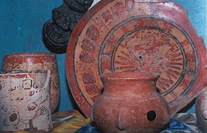
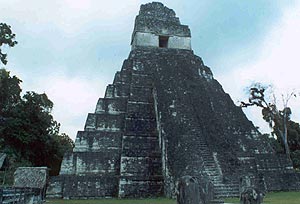
Was I a “furtive tourist?” I stayed for a few days, ate in all three of Uaxactún’s restaurants, and rented a bungalow room. But then I left, sending no new tourists their way, writing about my time there only long after the fact. Often during my two years of travels in Mexico and Central America, when I wrote about the communities I visited, I felt as if I were describing something about to disappear. I could almost feel the wave of destruction behind the line of my pen, wiping out the reality as fast as I could record it. Writing about Uaxactún, I don’t feel that way. It seems a hopeful act, a way of saying: Look at this. Let’s support other places like this. Still, the Sheraton hotels and helipads might be closing in on them. Tikal, perhaps the grandest of the excavated Maya ruins, sits 14 miles south of Uaxactún. Tikal’s Temple of the Giant Jaguar, which rises above the forest canopy to nearly 150 feet, is reproduced on everything from billboards to beer bottles in Guatemala. At its peak around 400 C.E., Tikal was home to perhaps 50,000 people. After it was abandoned in the ninth century, it lay nearly forgotten for a thousand years. These days, more than 130,000 tourists—nearly one in every three entering the country—visit the site each year. Too much of the money they spend ends up in the hands of people far from Petén. While a xate gatherer in Uaxactún earns an average of $5.15 a day—chicle and allspice harvesters earn even more—a waiter in a three-star hotel earns less than $2.50 a day and a maid, about $1.20. Around three-thousand years ago, a small village first appeared at Uaxactún. Like the residents in other small Maya villages at that time, the people at Uaxactún tended garden plots and made simple clay pots and bowls. They traded what they produced for obsidian, chert, salt, and other necessities. Two thousand years ago they began building pyramids from great stone blocks. They aligned their buildings with celestial movements, marking where the sun rose at the summer and winter solstices. They painted images of their kings and dieties in stucco on temple walls. A few centuries later, they began carving stelae, large stone monuments, to mark important events. They maintained relations with non-Maya communities, hosting guests from as far away as Teotihuacán, in what is now central Mexico. It was a bioregional community, as were all the communities of the Americas before the conquest.
Around 830 C.E., more than 400 years after Uaxactún had become subservient to Tikal, they stopped building the great temples. Within a few centuries, the stone city of Uaxactún lay in rubble among forest detritus. The people who lived there no longer could read the inscriptions on the stelae. Uaxactún reverted from a city with a few nobles, more artisans, and many slaves, to a village of subsistence farmers who grew their crops in isolation. Eventually, the villagers died out, or left. As with all the Maya communities, no one knows for sure why or how this happened. Many believe that a burgeoning population cleared too much forest, then faced a severe drought—with disastrous consequences. My second day in Uaxactún, I sat at a picnic table talking with Elfio Aldana, who rents several cabins in his yard to the backpackers who come to see the ruins. He was anxious to tell me his thoughts about the highway. “If they are going to destroy the forest, it would be better to just pay us for our houses and throw us out,” he said, arms wide and eyes furious. “We have spent so many years building this, maintaining the forest—for what?” Elfio looked hard at me. “This is supposedly a conservation reserve and they want to build a highway through it. So, are they really conservationists, or is it just us?”
|
|
||||||||||||||||||||||||||||||||||||||||||||||||||||||||||||||||