|
|
|
Done properly (i.e., with a substantial proportion of the unconstrained land set aside as permanent open space in squares, parks, greenways, and greenbelts), new villages and hamlets can be seen as an exciting, greener subset of "conservation design." Developer interest in creating more compact neighborhoods should be boosted by results from a recent survey by Fannie Mae, in which 75 percent of respondents said they believe living in a good neighborhood is more important than living in a good house. With the graying of the baby-boom generation, when every eight seconds someone in the United States turns 50, the market for homes on smaller lots, with plenty of community open space, is bound to grow significantly. There is the need for more livable neighborhoods in more complete communities, where open spaces are more than just the unbuildable land, plus an obligatory green or ball field.
When asked about the difference between my approach and that of my colleagues who are more active than I am in the New Urbanist movement, I typically respond that we are both very interested in promoting more compact forms of development. Whereas the tighter development pattern seems to be the principal goal of many New Urbanists (with land conservation being a felicitous byproduct), land protection is the main point for me and other landscape architects and conservation planners. The village approach is a means to achieving that end. This difference is also reflected in the ways that we generally approach the design challenge, with architects tending to place more emphasis on layout and streetscape issues and landscape architects and conservation planners assigning greater weight to a variety of sometimes subtle landscape features that we see as opportunities for shaping the ultimate design. The proponents of each perspective, however, have much to offer and learn from each other.
The idea of giving precedence to existing site features when they pose no real constraints is rooted deeply in the Garden City planning tradition. In a 1911 lecture to the Chicago Club, Raymond Unwin told the audience, "We began to realize that city planning must be a combination of the art of man and the beauty of nature.... We therefore preserved the trees and the hedgerows, so that the sites would not look so bare from the beginning." Excellent advice both then and now, but more's the pity that nearly 90 years later this should still be a novel idea to the majority of practicing site designers in this country.
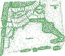
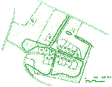
The pair of drawings in Figures 1 and 2 show two different ways of laying out a development in a field behind an old village in Maryland. One team of architects produced a design that appropriately extended the traditional pattern of interconnected streets and blocks, but in their desire to faithfully execute a layout worthy of a nineteenth century surveyor the designers repeated the mistakes of the past and pushed the streets out across the fields in an indiscriminate manner, irrespective of the trees and hedgerows that comprise important features of the cultural landscape. According to the developer, townspeople who knew the site very well were not impressed and described the layout as too rigid and urban. When the developer asked me to try my hand and produce a more "rural" design, I simply fit the elements into the three "outdoor rooms" created by the tree lines, and introduced at least one small open space into the center of each of those "rooms." In addition, the streets were deliberately curved in two of these instances so that the traveler's eye would rest upon the central greens. This design principle is also illustrated in Figure 4, which depicts a Virginia site for which I was asked to prepare a concept plan.
On another part of this village extension site illustrated in Figure 2, meadows, greens, and large freestanding trees were deliberately aligned with the sightlines of people driving or walking through the development. The sense of openness is also greatly enhanced through the liberal use of "single-loaded" streets, not only around greens and commons but also along part of the perimeter where the development borders large fields (Figure 5).
A similar approach was taken by Richard Calderon during his tenure at the Loudoun County Planning Department, in which capacity he prepared the design in Figure 6 to help a developer meet new zoning regulations governing village design. This example combines elements of earlier ones, with the layout following the pattern of hedgerows, and with woodlands and large "conservancy lots" that buffer the village grouping from view of the public road bounding one side of the site. The tree line was also used as an ordering element for the new access street serving the development, giving it an immediate and traditional sense of time and place.
In the dense second-growth woodland his father had bought for development at Tioga New Town near Gainesville, Florida, site designer Luis Diaz noticed what appeared to be continuous lines of larger trees among the rest. Further analysis revealed one of these lines to be the original hedgerow separating former fields now fully grown back into forest. It was discovered that the other feature, a double row of trees, had lined the lane leading to the site of the farmhouse, long since vanished. For Diaz, these revelations spurred ideas to lay out a new street along the first line to generate instant shade and a feeling of permanence to the new streetscape and also to create a formal greenway "esplanade" between the pair of parallel treelines (Figures 7 and 8).
|
|
||||||||||||||||||||||||||||||||||||||||||||||||||||||||||||||||